
Excerpted from Kiss Your Ash Goodbye: The Yellowstone Supervolcano,
© 2018
By Stephanie Osborn
Images in this article are public domain unless otherwise
noted.
How many supervolcanoes are there in North America?
There are ~170 active volcanos in the United States of America,
most in Alaska and Hawaii, though there are quite a few along the West Coast
states.
There are only an estimated 4-5 supervolcanoes in the USA.
These include the Yellowstone Caldera (VEI:7-8), Mt. Mazama/Crater Lake
(considered dormant) (VEI:7), Valles Caldera (VEI:7), Long Valley Caldera
(VEI:7), La Garita Caldera (likely extinct) (VEI:8), with all except the last potentially
capable of erupting. There were more, but they appear to be extinct. Extinct is
relative, however; most show some degree of geothermal activity in the area.
Mt. Mazama/Crater Lake (VEI:7)
The central feature of Crater Lake National Park is Mount
Mazama in southern Oregon. It is a composite volcano (a composite of
alternating layers of ash/cinder and lava) in the Cascade Volcanic Range of the
Pacific Northwest, which are fed by the subduction and subsequent melting of
the Pacific Ocean floor tectonic plates.
Prior to the caldera-forming eruption, Mazama stood at least ~12,000ft
(3,700m) in altitude. Post-eruption, it now has a maximum height of 8,934ft (2,723m)
at Mount Scott (2mi/3km east of the caldera rim), which is a parasitic cone on
the flank of the volcano. [Yes, that’s right, the caldera rim is some 800ft+
(240m+) lower.]
The caldera rim proper ranges from 7,000-8,000ft (2,100-2,400m)
altitude, and is 5x6mi (8.0x9.7km) across. The bottom of Crater Lake goes
2,148ft (655m) down; it is the deepest lake in the U.S. The lake IS the
caldera, so that's at least how far it collapsed. Some say that the bottom is
near the base of the mountain, others that it goes even deeper.
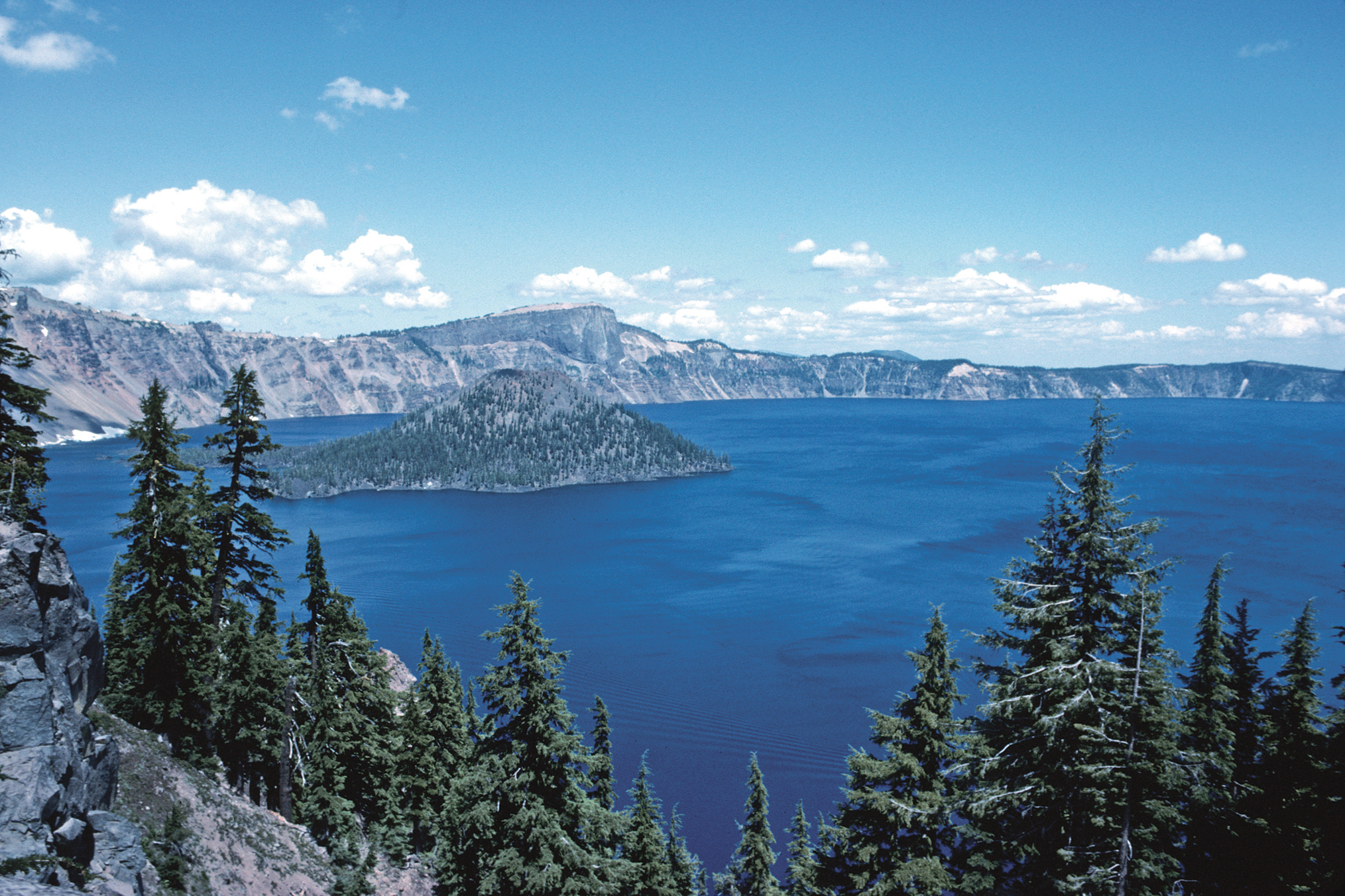
Crater Lake, the water-filled caldera of Mt. Mazama.
In relatively continuous eruption since 420,000 years ago, things
changed around 30,000 years ago, when the chemistry of the melt feeding the
magma chamber apparently began to change from a relatively basaltic, runny
magma to a much more viscous, silica-rich melt. As this melt grew thicker, the
eruptions became more violent.
The catastrophic eruption occurred 7,700 years ago, and was
observed by the local Klamath indigenous people, who “recorded” it in myth. It
“...started from a single vent on the northeast side of the volcano as a
towering column of pumice and ash that reached some 30mi (50km) high. Winds
carried the ash across much of the Pacific Northwest and parts of southern
Canada...As the summit collapsed, circular cracks opened up around the peak.
More magma erupted through these cracks to race down the slopes as pyroclastic
flows. Deposits from these flows partially filled the valleys around Mount Mazama
with up to 300ft (100m) of pumice and ash. As more magma erupted, the collapse
progressed until the dust settled to reveal a caldera, 5mi (8km) in diameter
and 1mi (1.6km) deep.” ~USGS website
Subsequent eruptions from vents inside the caldera created what
became Wizard Island, as snow- and glacier-melt slowly filled the depression.
Eventually eruption ceased, and the ruins of Mt. Mazama began to resemble the
beautiful Crater Lake we know today.
Mt. Mazama is officially considered dormant by the U.S. Geological
Society.
The Valles Caldera (VEI:7)
Sometimes called the Jimez Caldera, this supervolcano is
located in northern New Mexico, 55mi (90km) north of Albuquerque. It is named
for the numerous grassland valleys (Spanish: valles) contained within the circular
caldera, which is about 13.7mi (22km) in diameter. It is similar to Yellowstone
in that the caldera also contains hot springs, fumaroles (steam vents), gas
vents, and volcanic domes, in addition to meadows and streams.
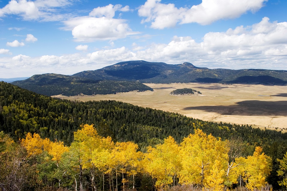
The Valles Caldera as viewed from the rim.
Note the
volcanic domes dotting the floor.
Credit: National Parks Service.
Geologically, it is one of the best-studied calderas in the
U.S. There are at least two known calderas on this site, the Valles, and the
older Toledo Caldera. The nearby and associated Cerros del Rio volcanic field
is older still, indicating multiple supereruptions at this site. Overall, these
and related nearby volcanic features are included within the Jemez Volcanic
Field & Mountain Range, which stretches across three counties in New
Mexico.
Several layers of silica-rich lava and tuff (welded ash) in
the region are ample proof of the eruptions, the most recent of which was some
50-60 thousand years ago and resulted in the current Valles caldera. Previous
eruptions date back at least 14 million years.
The cause of the vulcanism seems to be the intersection of
the Rio Grande Rift (a continental rift zone, running N-S from central Colorado
state, USA, to Chihuahua state, Mexico) and the Jemez Lineament (a series of
faults running E-W 600mi (965km) from Arizona east possibly as far as western
Oklahoma). The Valles Caldera does not, therefore, appear to be due to a
solitary mantle hotspot as such, but to rifting occurring in the middle of the
continental plate, though this rifting may be from convective uplift in the
mantle.
The Long Valley Caldera (VEI:7)
The Long Valley Caldera is in central California along and
slightly east of the westernmost Sierra Nevada Range. It and the adjacent
Mammoth Mountain/Mono-Inyo complex are around 55mi (89km) northeast of Fresno,
California.
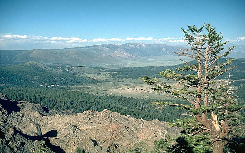
Part of the Long Valley Caldera,
looking east from the
north rim.
The caldera is ~20mi (32km) long, 10mi (16km) wide, and up to
3,000ft (910m) deep. It generated a massive supereruption some 760,000 years
ago, producing the Bishop Tuff formation. The grand total of ejecta was some
150cu.mi (625km3), after which the surface sank nearly a mile (1.6km) into what
had been the magma chamber.
The cause of the supereruption is unexplained; it is not
fueled by a mantle hotspot, nor is it provided melt via subduction.
More, while it is adjacent to still-active Mammoth Mountain
and the Mono-Inyo crater chain, and at least appears to be associated with
them, the magma chemistries are very different, indicating they do not share a
common melt system, and are NOT associated. This is an interesting puzzle.
“The caldera remains thermally active, with many hot springs
and fumaroles, and has had significant deformation, seismicity, and other
unrest in recent years.” ~USGS website
The activity is sufficient to run a geothermal power plant
located there. But how much of this activity is due to the Mono/Mammoth complex
and how much to the caldera source is not fully understood. Smaller eruptions
have occurred around the caldera on a semi-regular long period, but the lava
extruded has apparently been increasingly crystalline in nature, which may
indicate that the magma source is cooling significantly.
La Garita/Creede Caldera (VEI:8)
The La Garita caldera-forming eruption is estimated as one of
the largest eruptions on Earth. It lies in the midst of a huge region in the
Rocky Mountains called the San Juan Volcanic Fields. The town of Creede sits on
what would have been the north caldera rim, with Pueblo, Colorado 110-115mi
(km) east-northeast; Colorado Springs ~120mi (193km) northeast; Denver ~150mi
(240km) north-northeast.
This region became active some 35-40 million years ago, with
an exceptional period of activity from 30-35 million years ago. At the tail end
of this flurry of vulcanism, the La Garita supereruption took place, roughly 27
million years ago. It ejected some 1,200cu.mi. (5,000km3) of
material, which became known as the Fish Canyon Tuff. This ash deposit covered
an area of AT LEAST 11,000 sq.mi. (30,000km2) in a layer whose
average depth was 328ft (100m). This tuff is surprisingly uniform chemically, indicating
it was ejected all in a volume.
The resulting caldera was a monster 22mi (35km) wide, and
anywhere from 47-62mi (75-100km) long. It is no longer recognizable as such to
the untrained eye, however, as a single resurgent dome (Snowshoe Mountain) has
filled it.
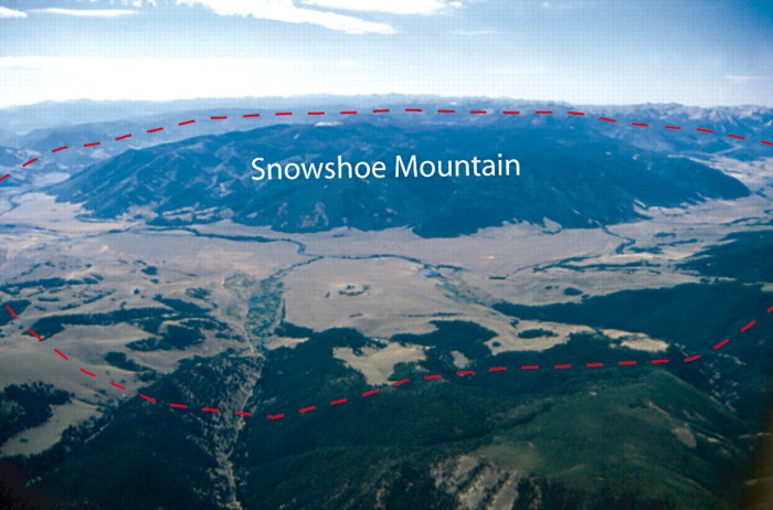
La Garita Caldera (red dotted outline),
with resurgent dome
(Snowshoe Mountain) inside it.
The energy of the eruption was some 5,000x the largest
nuclear device ever detonated on Earth, the Tsar Bomba, a 50MT explosive. This
places the La Garita supereruption at 250 GIGATONS of energy. The area
devastated would have encompassed a substantial portion of what is modern-day
Colorado, not counting ash fall.
Vulcanism in the San Juan Volcanic Field as a whole,
including the La Garita supervolcano, apparently ended 2.5 million years ago.
It is considered extinct.
What’s the strongest supervolcano ever known?
The biggest known eruption in geologic history IN THE USA —
some say in the world — was the Fish Canyon eruption in the La Garita
megacaldera.
The biggest known eruption in geologic history in the WORLD
was the Guarapuava-Tamarana-Sarusas eruption in South America. The eruption
occurred ~132 million years ago, produced an estimated 2,100 cu. mi. (8,600 km3)
of ejecta, and was probably at least the equivalent of the La Garita eruption.
To obtain a copy of Kiss
Your Ash Goodbye: The Yellowstone Supervolcano by Stephanie
Osborn, go to: http://bit.ly/Kin-KYAGTYSV.