Banner

Banner

Tuesday, October 16, 2018

Out, Damned Spot! Out, I Say! A Solar Activity Update

By Stephanie Osborn

My experience

I did my graduate work in spotted variable stars at Vanderbilt University, so in the astronomical community I would be considered a variable star astronomer. Based on our experience, many variable star astronomers consider the Sun to be at least borderline variable, and I am one of these. In point of fact, pretty much across the board, astronomers dropped the “solar constant” years ago, because it simply wasn’t. (Unfortunately, other disciplines have not.)

I personally have been watching solar activity for many years now and have watched the activity gradually decrease. As a consequence, I began keeping a rough spreadsheet in summer 2016 as I watched activity begin to drop dramatically. So I have about 2 years of recorded data. It is fairly simplistic, because I only wanted a snapshot and didn’t have time to do more detail, but it serves the purpose, as we will see shortly.

The current solar cycle

This graph is the latter part of solar cycle 23 and all of cycle 24, roughly to date. (Note, however, that the plot ends in ~March 2018. It’s very difficult to find plots that are current to the month.) The red line is the projected curve. The blue line is the smoothed curve. The purple dots and jagged line are the actual data.


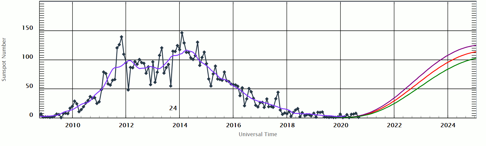
Note that the peak for 24 was approximately half that of 23. Also note that we are currently already as low as the minimum that ended cycle 23, at approximately 8.5-9 years into an average-11-year cycle. Theoretically, we still have a couple of years to go before the actual minimum is reached, though 11 years IS an average.

Recent solar cycles

Here is a graph presenting solar cycles 14-24(current). This takes us back to around 1900AD. Note the decrease in the height of the peak (solar max) of each cycle since ~1980. Note the decreased activity in cycle 20. Note the gradual increase in peak height from 1900-1960, though there is a slight drop in cycle 16, around 1930.


Long-term observations

This next chart goes back a LITTLE farther. This is a view of activity over the last 400 years. Note that this graph does NOT include cycle 24; it stops at 23. Cycle 24 is already at roughly the same level as the cycles found in the Dalton Extended Minimum, and this has been noted by several groups with experience in the field.


An interesting correlation

This is a clipping from a Michigan newspaper which was sent to me a couple of months ago. Note the article date written in the margin.


Correlate this to the very low peak of solar cycle 20, which occurred during the 1970s. Note the snow event in 1942, in the cycle subsequent to the diminished cycle 16. Also consider the “Little Ice Age,” which was a prolonged cool period (~1300-1900) overarching the four back-to-back extended minima: the Wolf, Spörer, Maunder, and Dalton Minima (running ~1280-1850AD). Also note the year 1816, the so-called Year Without A Summer, aka “Poverty Year” and “Eighteen Hundred and Froze to Death,” which occurred during the Dalton Minimum (~1790-1830; some argue a later end).

My data (2016)


Legend:
Column 1 is the year.
Column 2 is the month.
Column 3 is the percentage of days in that month with no more than 1 sunspot/sunspot group.
Column 4 is the percentage of days in that month with NO sunspots.

My data (2017)


My data (2018 incomplete)


My data, graphed (total)


Legend:
The dark green line represents the percentage of days in any given month with no more than 1 numbered sunspot group.
The light green line represents the percentage of days in any given month with no sunspot group.
The latest data

I haven’t had a chance to include the last couple of months of data in the charts as yet. However, in brief synopsis, May had 77.4% of days with no more than 1 sunspot group, and two sets of seven consecutive spotless days. June was much the same, with another spotless week early on; another session of spotless days began June 27th...and continued through the entirety of July. Today, as I write this, it is July 31st, and we have had 35 consecutive spotless days. Since it takes about 24.5 days for the solar equatorial regions to rotate once around its axis, this means that we have seen the entire photosphere spotless; not even the solar farside has spots, and this appears to be corroborated by the STEREO solar observing platforms. A couple of short-lived, almost-spot plages developed during this period, on July 3rd and 21st, but otherwise there were no visible photospheric features. Virtually the only other solar activity came from the enhanced solar wind streams from coronal holes, and even those are diminishing in size and strength.

Other solar activity

Flare numbers are decreasing; CME numbers are decreasing. BUT cosmic ray flux is increasing. Why? And what do all those words mean, anyway?

Sunspots, flares, and coronal mass ejections (CMEs) are all related; flares tend to produce CMEs, and tend to form near spots. This is because they are all magnetic events. A sunspot is believed to be the “snarl” produced in the magnetic field lines as a result of differential rotation — since the Sun is not a solid body, it does not rotate uniformly; rather, it follows Kepler’s Laws of orbital motion. The poles rotate faster than the equator, and the interior rotates faster than the photosphere. But since it is a plasma body, and plasma is composed of charged particles, it generates a strong magnetic field. As this differential rotation proceeds, the field lines gradually wrap up. If (among other things) local inhomogeneities occur, the field strength can vary, and the field lines may “snarl.” But they also tend to move upward as the plasma convects. When the snarls reach the photosphere — the visible surface — they are slightly cooler, hence darker, and appear as sunspots.

But these snarls contain carp-tons of magnetic potential energy. And from time to time, that potential energy manages to release itself, in the form of a magnetic reconnection event. This is, in essence, the field trying to simplify itself and untangle, after a fashion — the field lines break here and reattach over there, in an effort to reshape themselves and eliminate the snarl. This converts the potential energy into tremendous amounts of other kinds of energy — thermal and kinetic, to name a couple — and the result is a flare. This explosive event can — but does not always then generate the equivalent of a mushroom cloud, which blows off the photosphere into the solar system, accelerated by the reconfiguring magnetic fields. This “mushroom cloud” is the CME.

Given that this differential rotation creates an extremely complex overall magnetic field, sometimes field lines leave the Sun and stretch off — essentially to infinity — in places not normal for a typical dipole (bar) magnet, which ordinarily would mean JUST the poles. These regions of “infinite field lines” are visible in certain wavelengths of light as darker regions, due to the relative lack of plasma in the inner corona, and they are called coronal holes. The solar wind tends to be “enhanced” along these field lines, since the magnetic field is effectively accelerating the plasma in these regions. They are strong, and can create minor geomagnetic storming and aurorae on Earth (or the other planets) if we pass through that enhanced wind stream, but it won’t be as strong as getting hit with a big CME.

Cosmic rays are generally subatomic particles of various sorts, originating from outside our solar system — sometimes outside our galaxy. They are extremely energetic and are produced by the more powerful cosmic objects out there: pulsars, magnetars, supernovae, black hole accretion disks, even quasars. They can be dangerous precisely because they are so energetic, and often if they hit an object, they produce a cascade of additional particles. (In atmosphere, this is called a cosmic ray shower.)

BUT, since most of them are charged particles they’d be incredibly hot plasma if you got enough of ‘em together in one place — they can be deflected by magnetic fields. And woo-ha, a moving plasma such as the solar wind constitutes a current, which in turn generates an interplanetary magnetic field! So this magnetic field protects the inner solar system from potentially deadly cosmic radiation. (The term “flux” simply means you’re measuring the number of such particles passing through a given area — typically a square meter — per second.)

So. The stronger the interplanetary magnetic field, the better the protection we have from cosmic rays, and the lower the cosmic ray flux will be.

BUT.

When the Sun is less active, the slower and less dense the solar wind will be, hence the weaker the interplanetary field will be.

So we would expect that an active Sun would mean a low cosmic ray flux, and an inactive Sun would mean a higher cosmic ray flux...and this is exactly what we see. More, as the solar activity has diminished in recent years, we have watched the cosmic ray flux increase.


Credit: graph from spaceweather.com

Note: Stratospheric flux tends to be more representative of solar system fluxes than lower-altitude measurements; this is because the atmosphere attenuates the rays. Note how the flux has increased from 78x to 88x that found at sea level.

My thoughts

Based on all this information, it is my considered opinion that we are about to enter an extended minimum, if we are not already in one. The double-dynamo solar model predicted one more solar cycle before entering an extended minimum. However, this model, while able to accurately recreate the shapes of recent solar cycles, has been unable to adequately model historic extended minima. It must therefore be concluded that it is not complete. It is my educated conclusion that it does not go far enough, and there is at least one more dynamo which needs to be modeled. It is therefore likely that the onset and the exit of the predicted extended minimum may be “squishy,” and the dates may vary by as much as a solar cycle or more.

It is very true that “correlation does not equal causation,” but when correlations begin to mount, it is foolhardy to refuse to consider the possibility of a coupling mechanism. To name a few correlations:
·         Greenland/Vinland settlement around 1000AD/tail end of the Roman Warm Period
·         The Little Ice Age/four consecutive extended minima
·         The Year Without A Summer/Dalton Minimum
·         Snow in summer in 1942/low-activity Cycle 16 preceding
·         Snow in summer in 1979/low-activity Cycle 20 preceding
·         Modern Warm Period/increasing solar activity in 1st half 20th Century
·         Plateau in warming in the 2000’s/gradual decrease in solar activity since ~1980
Yes, certainly volcanic eruptions and other events factor into the situation. But how many correlations does it take before we need to sit up and take notice? Before we seriously start to wonder what is really going on?

For more on solar activity, check out The Weather Out There Is Frightful , by Stephanie Osborn. 

Tuesday, October 9, 2018

Kiss Your Ash Goodbye: The Yellowstone Supervolcano, Part V, A Vulcanology Primer


By Stephanie Osborn
Images in this article are public domain unless otherwise noted.

What Would Happen If Yellowstone Erupted Today?

That would depend on the type of eruption. Because, you see, sometimes Yellowstone vomits, sometimes it coughs, and sometimes it only sneezes.

The Sneeze: Hydrothermal/Phreatic Eruptions

A hydrothermal or phreatic eruption is by far the most common occurrence at Yellowstone. Put simply, it’s a cross between a boiler explosion and a geyser, and at least at Yellowstone, often leaves new geysers or hot springs in its wake. The USGS’s definition is as follows: “[A hydrothermal eruption is an] explosion that can occur when hot water within a volcano’s hydrothermal (hot water) system flashes to steam, breaking rocks and throwing them into the air.” And often throwing them a good distance...though NOT nearly as far as a standard volcanic eruption can chuck a lava bomb.
It does happen, and has happened in living memory — Porkchop Geyser in the Norris Geyser Basin was formed in this fashion in 1989. More historically, Excelsior Geyser generated a large, violent hydrothermal eruption in 1888, which was captured on film; it had been erupting in this fashion off and on through the 1880s-90s. Duck Lake, the ENTIRE LAKE, is the crater formed by such a hydrothermal eruption.


Hydrothermal explosion at Biscuit Basin in Yellowstone National Park.
Credit: USGS

IMPORTANT NOTE: Even when not in an active eruption, Yellowstone’s hydrothermal features are dangerous; some 22 people have died from falling into scalding hot springs since records began in 1870. One of the most recent, which occurred in 2016 in or in the near vicinity of Porkchop, resulted in the partial dissolution of the body before it could be recovered, thanks to the fact that the spring was essentially boiling acid; park rangers said had it taken much longer to recover the body, there would have been no body left to recover. (What was the victim going to do, according to his sister, who saw the whole horrible thing? He was going to take a hot tub bath in it. He fell in while trying to take the temperature of the water, when the thin, fragile mineral deposit on which he stood gave way.)

Yellowstone is far from the only volcano which generates such eruptions; I have been present for numerous such eruptions at Mount Saint Helens. There, they are usually called phreatic eruptions, and may carry some ash along with the steam vents. They are fairly common occurrences, and take place anywhere there is snow, ice, or other groundwater source in close proximity to magma.
Hydrothermal eruptions at Yellowstone are localized to the vicinity of the explosion, and do not affect the park as a whole. They can present a danger to bystanders, however, if observers are in the way of either the large rock ejecta or the scalding and often highly acidic water/steam.

This is THE MOST LIKELY TYPE OF ERUPTION to occur at Yellowstone.

The Cough: Ordinary Eruptions

The last “ordinary” eruption to occur at the Yellowstone hotspot happened only 70,000 years ago — yesterday, geologically-speaking. These tend to form fairly common lava flows, and may be somewhat eruptive (though trap-type flows have also occurred, according to geological evidence). It would devastate the park, and possibly some of the surrounding land, depending on exactly where and how the lava surfaced, but would not necessarily induce a supervolcanic eruption if there is insufficient pressure, or if the “surface shadow” of the underground melt is not large.
This is the second most likely type of eruption to occur at Yellowstone.


Yellowstone caldera’s northwest rim at Madison Junction in Yellowstone National Park. 
Note the presence of two overlapping lava flows from “ordinary” volcanic eruptions. 
Credit: USGS.

The Vomit: Super-eruptions

Super-eruptions take a fairly long time to develop, but as they progress, they accelerate. It can take anywhere from millennia to mere decades for the magma chamber to inflate and the signs to manifest, but once the chamber roof cracks all the way through from the surface, the rest takes place in a matter of minutes to seconds.

Once the cap has broken up, a giant plume develops some 12-20mi (20-32km) high. The initial plume collapses to form a giant pyroclastic flow that wipes everything out within 60-100mi (100-160km). Anything closer than 125-200 mi (200-325 km) is buried under vast amounts of ash and roofed/covered structures collapse within hours to days; aircraft can no longer fly over western USA/Canada, rapidly progressing to all of North America as the ash cloud spreads. Vehicles stall when air intakes choke on ash. Mud flows form in rainy areas. The first cases of silicosis develop.  The ash cloud sweeps worldwide, reaching Europe in ~3 days. Global temperatures drop, and Earth enters a volcanic winter.

Modeled Extent of Ashfall in a Modern Super-eruption

Even Chicago would get up to an inch or more of ash, and the East Coast gets a solid dusting. The west coast of USA, Canada, and northern Mexico get no favors, either. The grain belt would be devastated in a matter of hours.

Some FEMA researchers estimate the US could take as much as $3 trillion in damage/loss. Other experts say that as much as 2/3 of the USA could be rendered uninhabitable.


The modeled extent of ashfall, 
with depth decreasing with increasing distance, 
of a modern-day Yellowstone supereruption. 
Credit: USGS.

Don’t Panic!

A supereruption is the LEAST likely type of eruption to occur. There are far too many panic-mongers out there.

The 2018 “Incident” That Wasn’t

While I was writing the ebook, I was pinged on social media about A DREADFUL SITUATION! OH NOES! HUGE FISSURE OPENS UP INSIDE YELLOWSTONE SUPERVOLCANO, AREA AROUND FISSURE CLOSED! ERUPTION IMMINENT!!! or impressions to that effect.
Well, I took one good look at the article’s source and snorted. And then I got busy researching.
It turns out there was a JOINT FRACTURE in the rock above Hidden Falls in GRAND TETON NATIONAL PARK, NOT Yellowstone National Park, and some SIXTY MILES (100km) from Yellowstone. The crack was HORIZONTAL (not vertical, therefore NOT able to reach down toward a magma chamber, which does not currently have sufficient melt in it to even inflate, anyway), and was considered a rock fall hazard, hence the real reason why the immediate area was closed by the Park Service. Cause of the fracture was most likely the usual freezing/thawing process that causes such things in mountain ranges.


Hidden Falls in Grand Tetons National Park.
Credit: National Parks Service.

The 2004 Incident

In 2004, there was a small kill-off of animals in Yellowstone, notably about half a dozen bison, in a hollow along the Gibbon River inside the park. This, as well as the slight inflation of the Yellowstone Lake bed, resulted in significant concern among both geologists and the public that the magma chamber was inflating and the caldera becoming active.


A nursery group of bison cows and calves makes its way through Lamar Valley in Yellowstone. Credit: National Parks Service/Neal Herbert.


However, that proved not quite the case.

You see, the caldera area “breathes.” Elevations go up and down by small amounts. Sometimes this is because the magma chamber is inflating, and sometimes it isn’t. In this case, the DEEP chamber (NOT the shallow chamber, from whence an eruption comes) had in fact had fresh magma pumped in, but the quantity was small, and it periodically slows, stops, or even reverses. Scientists believe this is because the “fresh” magma, upon reaching the bottom of the upper chamber, then flows away through deep horizontal vents (rather like what Kilauea is doing now), to cool and form plutons — small to very large bodies of underground, intruded, solidified igneous rock.

Often this ground swell is also because there is a tremendous quantity of ground water heated by the (mostly-solid but still hot) upper magma chamber. And when water is heated, it expands. As the heated ground water ebbs and flows, the ground in the area swells and shrinks. This, in turn, tends to change the activity of the hydrothermal features, increasing or decreasing with the pressure of ground water.

That last bit is important, because the animal-kill event occurred shortly after a cold front passage, when the air was frigid and still, and the animals took shelter in a low-lying area near the river, where those same hydrothermal features would help keep the air warm, and make foraging for food easier. Hydrothermal features such as those found nearby are also known to emit toxic volcanic gases such as sulfur dioxide, hydrogen sulfide, and carbon dioxide, often in significant quantities, WITHOUT the need for an eruptive event — pretty much continuously. And these gases, mostly being heavier than air, tend to flow along the ground and collect in low-lying areas. Normally, the winds in the region keep the air sufficiently stirred that concentration is not particularly dangerous, but certain meteorological conditions — such as those brought about by the cold front passage — can result in air that is sufficiently still to allow the vapors to collect and concentrate, and this appears to be what happened in 2004.

And this has happened before, several times in recorded history. This does NOT mean that the caldera is preparing to erupt. Nor does it mean that such an eruption, IF it took place, would automatically be a supereruption, as “ordinary” eruptions are more common, based on geologic studies.

But What if it DID erupt? 

What do you do?

Kiss your ash goodbye...?

No, seriously. What do you do?

In all seriousness? Unfortunately, there are some natural disasters for which it simply isn’t possible to do a lot of advance preparation. They are simply too big, too widespread, and too variable, to make plans. Supervolcano eruptions are one of these. Physicist Michio Kaku said it best, I think...

“All you can do is run.”
~Michio Kaku

To obtain a copy of Kiss Your Ash Goodbye: The Yellowstone Supervolcano by Stephanie Osborn, go to: bit.ly/Kin-KYAGTYSV.

Tuesday, October 2, 2018

Kiss Your Ash Goodbye: The Yellowstone Supervolcano, Part IV, A Vulcanology Primer

Excerpted from Kiss Your Ash Goodbye: The Yellowstone Supervolcano, © 2018
By Stephanie Osborn
http://www.stephanie-osborn.com
Images in this article are public domain unless otherwise noted.

Geological History — Known Yellowstone Eruptions

There have been 3 known “Yellowstone” eruptions with detectable welded-ash (which forms a rock called “tuff”) strata, all of which occurred in approximately the same location:
1) Island Park/Huckleberry Ridge
2) Henry’s Fork/Mesa Falls
3) Yellowstone/Lava Creek


A map depicting the ash bed strata for all three major Yellowstone supereruptions, 
along with the Long Valley eruption’s Bishop ash bed, 
and the Mt. St. Helens ash fall, for comparison.
Credit: USGS.

The Island Park/Huckleberry Ridge Eruption

The Huckleberry Ridge Eruption is the oldest eruption at the current location, some 2.1 million years ago. The caldera formed by this eruption is known as the Island Park Caldera; the stratum of tuff (also “tufa”; a kind of rock composed of welded ash — upon landing, the ash was still hot enough to be partly molten, and the particles literally stuck together, or “welded,” into a single rock layer; it is often porous, fine-grained, but may contain larger, pebble-like particles, especially close to the eruptive source) is the Huckleberry Ridge Tuff.


Etruscan paving stones composed of tuff from the Italian peninsula.


One of the world’s largest calderas, the Island Park Caldera is at a minimum 50x40mi (80x65km) up to possibly as large as 60x37mi (95x60km) and possibly up to ~0.6mi (1km) deep. This would have been bigger than the state of Rhode Island. The eruption was 2,500x greater than Mt. St. Helens.


Exposed Huckleberry Ridge tuff strata 
(there were several ashfalls in quick succession here) 
along the Gardner River near Osprey Falls, 
above Mammoth Hot Springs in WY.
Note vehicles for scale.

The Henry’s Fork/Mesa Falls Eruption

The Mesa Falls eruption occurred 1.3 million years ago and produced the Henry’s Fork caldera along with the Mesa Falls Tuff. The Henry’s Fork megacaldera is approximately 18x23mi (11x14km) in dimension, though some argue for a rounder shape, anywhere from 10-20mi (16-32km) in diameter.
This was “only” a VEI 7 eruption, but partly due to its density, and partly its overall size, it is considered a supervolcano eruption.


Exposed Mesa Falls tuff at south rim of the Island Park Caldera/Henry's Fork Caldera overlap; 
near Ashton, ID. Note vehicle for scale.

The Yellowstone/Lava Creek Eruption

This eruption is the most recent supereruption, and the only one dubbed “Yellowstone”; it occurred “only” ~630,000-640,000 years ago and produced the current Yellowstone caldera, creating the Lava Creek Tuff formation. The current caldera measures 53x28mi (85x45km). The current caldera rim ranges from some 100ft (30m) tall up to nearly a third of a mile (500m) high. This was without doubt a VEI 8 eruption.


Tuff Cliff in Yellowstone National Park, 
showing an exposed section of the Lava Creek tuff.


NOTE: It is essential to realize that the maps depict THE EXTENT OF THE TUFF STRATUM FOR EACH ERUPTION, and do NOT indicate the full extent of the ASH FALL. As aforementioned, tuff is formed when the falling ash is still hot enough to be partly molten, so the particles stick together when they contact. Ash can and does fall far beyond the extent of the formation of tuff — the ash plume from a Yellowstone super-eruption would be caught up in the jet streams and swept worldwide.

Other Yellowstone Activity

So. Three honkin’ big eruptions from the Yellowstone hotspot, huh? Well, really, that’s not a huge record. There’s not that much to worry about, is there?

Except for the fact that the Yellowstone hotspot has been busy. And it’s been around for MILLIONS of years.

Yellowstone hotspot eruptions can be tracked from their current location in the corner where Wyoming, Montana, & Idaho meet, all the way back in a southwest direction nearly to the northeast corner of California — as many as a dozen or more! The oldest known eruption dates to at least 16-18 million years ago.


Location of some of the previous Yellowstone-hotspot calderas, with ages indicated.
Credit: Kelvin Case at English Wikipedia, CC BY 3.0, 


A different version of the map, showing other areal features, 
including a few members of the Cascade volcanic chain, 
and the Columbia Flood Basalts, a trap eruption which may or 
may not be associated with the hotspot.
Credit: Lori Snyder, Department of Geology, University of Wisconsin-Eau Claire, via USGS

Also realize that the Rocky Mountains orogeny (mountain-building) ended some 55 million years ago, meaning they were already formed before the Yellowstone hotspot got to them...yet, aside from some resurgent domes, etc., there are essentially NO mountains in the hotspot track — at least within the megacalderas.

The mantle plume/hotspot is NOT moving relative to the Earth’s surface overall, nor with respect to the Earth’s core. Plate tectonics creates the appearance that it is moving, when it is really the North American plate moving across the hotspot. The track of past calderas punched through the plate is therefore an inverse record of the direction of movement of the North American plate. The North American Plate is moving roughly southwest to west-southwest, with slight changes in direction over time. This accounts for the direction and slight curvature of the caldera track.

To obtain a copy of Kiss Your Ash Goodbye: The Yellowstone Supervolcano by Stephanie Osborn, go to: http://bit.ly/Kin-KYAGTYSV.

Tuesday, September 25, 2018

Kiss Your Ash Goodbye: The Yellowstone Supervolcano, Part III, A Vulcanology Primer


By Stephanie Osborn
Images in this article are public domain unless otherwise noted.

The Yellowstone Hotspot and Structure

NOTE: I am aware that there is current research claiming that the subducted Farallon Plate is the source of the Yellowstone melt, as well as its long-lived behavior and track. However, based on what I know, I am skeptical.

For now, in the absence of more definitive results, and given the fact that the ancient plate is now pretty much crammed almost as far under the eastern North American plate as it can get and still be under it, and given detailed information on a mantle plume of some substantial size, it is my considered opinion that more than likely, the Farallon Plate had only marginal, if any, effects on Yellowstone. That said, it may possibly be at least part of the reason why said mantle plume is anything but vertical. (I do discuss all this in a bit more detail in the ebook.)

I also note that the current accepted model is “mantle hotspot,” with plenty of data to support it. If that should change, I will add an update.

Overview

The Yellowstone supervolcano is a very long-lived system. Unlike most more ordinary volcanoes, which are supplied with magma via such relatively shallow means as tectonic plate subduction and subsequent melting, Yellowstone is apparently produced by a large and powerful mantle plume; the reason for the plume is unknown. As the melt in the plume rises, it pushes on the overlying crust, “puddling” in a weakness in the overlying rock, forming a magma chamber. This pressure first forms a bulge (a “dome”), then the crust of the bulge begins to crack (surface cracks). If these cracks deepen enough to reach the magma chamber, an eruption can occur. They are also responsible for the hydrothermal features seen in the national park.

The Plume

The mantle plume goes down at least 600mi (~966km), but recent seismic evidence discovered by researchers at the University of Texas indicates it may go as far down as the outer core/mantle boundary, some 1,800mi (~2,900km) down. The plume apparently angles sharply south-southwest from the megacaldera, and the base of the plume can be found under the California/Mexico border. It is very roughly cylindrical; early estimates indicated it was some 215-300mi (346-483km) in diameter, but more recent estimates say it is at least 400mi (644km) wide. It is 2,050mi (3,300km) long, and up to 1,500ÂşF (816ÂşC) at the base, near the core.

The Magma Chambers

There are a couple of different reconstructions from seismic & other data that indicate the possible shape & size of the magma chamber. More, seismic tomography indicates there are TWO, a shallow and a deep chamber, with the deep chamber likely directly linked to the mantle plume.


The deep magma chamber, connected to the upper mantle plume.
Note state lines and park/caldera outlines on top and bottom of cube, for scale.

According to the USGS, “The shallower magma storage region is about 90km (56mi) long, [and] extends from 5-17km (3-10.5mi) depth.”

In turn, and from the same source, “The deeper magma storage region extends from 20-50km (12-31mi) depth, contains about 2% melt, and is about 4.5 times larger than the shallow magma body.”
If we assume based on those measurements average values for length, width, and height, such that the smaller chamber is a rough prolate ellipsoid of approximate dimension 7.5x7.5x56mi (12x12x90km), then it has a rough volume of ~13,000cu. mi. (~54,000km3). This then gives a volume for the deeper chamber of 58,500cu. mi. (~244,000km3).

However, as it turns out, generally speaking, magma chambers don’t induce eruption until they have surpassed the 50%-full mark. And that’s a whole heck of a lot of magma, AND we’re only at 2%. On general principles, I think we’re good.

The Geysers/Hydrothermal Features

The geysers, hot springs, mud pots, fumaroles, and the like are fed by ancient rain- and meltwaters — the local ground water, in essence, except it is often coming from depth — that seep through the network of cracks and fractures in the rock. They are heated by the chambers and gradually rise, eventually forcing their way to the surface to form geysers and all the other hydrothermal features common to Yellowstone and other such similar volcanic landscapes.


Riverside Geyser. Credit: National Park Service.


A fumarole (steam vent) field in Yellowstone, where dangerously superheated steam emerges in the geyser basins. Credit: National Park Service /Jim Peaco

WARNING: most of the hydrothermal features in Yellowstone, and other active megacalderas, are DANGEROUSLY HOT. Not infrequently, these are superheated waters, meaning their temperatures may well be above the boiling temperature of water; this is especially true for geysers and fumaroles, but many — most — hot springs are also near boiling. More, at least at Yellowstone, they also are prone to being highly acidic. It is NOT AN EXAGGERATION in the least to say that entering one of these features means an instant, horrible death; it has happened many times. Worse, sometimes bodies are not recovered, simply because the water has become strongly acidic thanks to the sulfuric gases dissolved in it; the corpses simply dissolve. When the bodies are recovered, they are often in very poor condition. DO NOT EVEN THINK OF TRYING to use one as your personal hot tub, and DO NOT LEAVE THE TRAILS/WALKWAYS, because the high mineral content can form what LOOKS like solid ground, but is really a skim of mineral deposits floating on the water’s surface.

Is There Any Danger of Eruption?

Yes, because this is an active volcanic feature; there has been some uplift in areas of the park, especially under the lake, but given the nature of the feature, and the high levels of seismic activity that occur there normally, that isn’t necessarily anything to worry about. The “uplift” feature on the lake floor seems to be part of an underwater field of hydrothermal vents, fissures and faults, not unlike those found on ocean floors, so it is likely that the uplift is a result of gases and expanding hot water underneath. Certainly a good deal of the seismic activity in and around the caldera has to do with this same hydrothermal activity; this expansion, when the water is in the natural cracks of a rock stratum, will force the cracks wider until the stone eventually breaks. This fracture does create small quakes.

So-called “quake swarms” in the region are NOT in the correct area to indicate magma on the move. They also don’t have the “long-period harmonic” vibrational component to indicate flowing magma. More, detailed geophysical studies show no evidence of either magma chamber inflating.

To obtain a copy of Kiss Your Ash Goodbye: The Yellowstone Supervolcano by Stephanie Osborn, go to: bit.ly/Kin-KYAGTYSV.

Tuesday, September 18, 2018

Kiss Your Ash Goodbye: The Yellowstone Supervolcano, Part II, A Vulcanology Primer


By Stephanie Osborn
Images in this article are public domain unless otherwise noted.

 How many supervolcanoes are there in North America?

There are ~170 active volcanos in the United States of America, most in Alaska and Hawaii, though there are quite a few along the West Coast states.

There are only an estimated 4-5 supervolcanoes in the USA. These include the Yellowstone Caldera (VEI:7-8), Mt. Mazama/Crater Lake (considered dormant) (VEI:7), Valles Caldera (VEI:7), Long Valley Caldera (VEI:7), La Garita Caldera (likely extinct) (VEI:8), with all except the last potentially capable of erupting. There were more, but they appear to be extinct. Extinct is relative, however; most show some degree of geothermal activity in the area.

Mt. Mazama/Crater Lake (VEI:7)

The central feature of Crater Lake National Park is Mount Mazama in southern Oregon. It is a composite volcano (a composite of alternating layers of ash/cinder and lava) in the Cascade Volcanic Range of the Pacific Northwest, which are fed by the subduction and subsequent melting of the Pacific Ocean floor tectonic plates.

Prior to the caldera-forming eruption, Mazama stood at least ~12,000ft (3,700m) in altitude. Post-eruption, it now has a maximum height of 8,934ft (2,723m) at Mount Scott (2mi/3km east of the caldera rim), which is a parasitic cone on the flank of the volcano. [Yes, that’s right, the caldera rim is some 800ft+ (240m+) lower.]

The caldera rim proper ranges from 7,000-8,000ft (2,100-2,400m) altitude, and is 5x6mi (8.0x9.7km) across. The bottom of Crater Lake goes 2,148ft (655m) down; it is the deepest lake in the U.S. The lake IS the caldera, so that's at least how far it collapsed. Some say that the bottom is near the base of the mountain, others that it goes even deeper.


Crater Lake, the water-filled caldera of Mt. Mazama.

In relatively continuous eruption since 420,000 years ago, things changed around 30,000 years ago, when the chemistry of the melt feeding the magma chamber apparently began to change from a relatively basaltic, runny magma to a much more viscous, silica-rich melt. As this melt grew thicker, the eruptions became more violent.

The catastrophic eruption occurred 7,700 years ago, and was observed by the local Klamath indigenous people, who “recorded” it in myth. It “...started from a single vent on the northeast side of the volcano as a towering column of pumice and ash that reached some 30mi (50km) high. Winds carried the ash across much of the Pacific Northwest and parts of southern Canada...As the summit collapsed, circular cracks opened up around the peak. More magma erupted through these cracks to race down the slopes as pyroclastic flows. Deposits from these flows partially filled the valleys around Mount Mazama with up to 300ft (100m) of pumice and ash. As more magma erupted, the collapse progressed until the dust settled to reveal a caldera, 5mi (8km) in diameter and 1mi (1.6km) deep.” ~USGS website

Subsequent eruptions from vents inside the caldera created what became Wizard Island, as snow- and glacier-melt slowly filled the depression. Eventually eruption ceased, and the ruins of Mt. Mazama began to resemble the beautiful Crater Lake we know today.

Mt. Mazama is officially considered dormant by the U.S. Geological Society.

The Valles Caldera (VEI:7)

Sometimes called the Jimez Caldera, this supervolcano is located in northern New Mexico, 55mi (90km) north of Albuquerque. It is named for the numerous grassland valleys (Spanish: valles) contained within the circular caldera, which is about 13.7mi (22km) in diameter. It is similar to Yellowstone in that the caldera also contains hot springs, fumaroles (steam vents), gas vents, and volcanic domes, in addition to meadows and streams.


The Valles Caldera as viewed from the rim. 
Note the volcanic domes dotting the floor.
Credit: National Parks Service.

Geologically, it is one of the best-studied calderas in the U.S. There are at least two known calderas on this site, the Valles, and the older Toledo Caldera. The nearby and associated Cerros del Rio volcanic field is older still, indicating multiple supereruptions at this site. Overall, these and related nearby volcanic features are included within the Jemez Volcanic Field & Mountain Range, which stretches across three counties in New Mexico.

Several layers of silica-rich lava and tuff (welded ash) in the region are ample proof of the eruptions, the most recent of which was some 50-60 thousand years ago and resulted in the current Valles caldera. Previous eruptions date back at least 14 million years.

The cause of the vulcanism seems to be the intersection of the Rio Grande Rift (a continental rift zone, running N-S from central Colorado state, USA, to Chihuahua state, Mexico) and the Jemez Lineament (a series of faults running E-W 600mi (965km) from Arizona east possibly as far as western Oklahoma). The Valles Caldera does not, therefore, appear to be due to a solitary mantle hotspot as such, but to rifting occurring in the middle of the continental plate, though this rifting may be from convective uplift in the mantle.

The Long Valley Caldera (VEI:7)

The Long Valley Caldera is in central California along and slightly east of the westernmost Sierra Nevada Range. It and the adjacent Mammoth Mountain/Mono-Inyo complex are around 55mi (89km) northeast of Fresno, California.


Part of the Long Valley Caldera, 
looking east from the north rim.

The caldera is ~20mi (32km) long, 10mi (16km) wide, and up to 3,000ft (910m) deep. It generated a massive supereruption some 760,000 years ago, producing the Bishop Tuff formation. The grand total of ejecta was some 150cu.mi (625km3), after which the surface sank nearly a mile (1.6km) into what had been the magma chamber.

The cause of the supereruption is unexplained; it is not fueled by a mantle hotspot, nor is it provided melt via subduction.

More, while it is adjacent to still-active Mammoth Mountain and the Mono-Inyo crater chain, and at least appears to be associated with them, the magma chemistries are very different, indicating they do not share a common melt system, and are NOT associated. This is an interesting puzzle.

“The caldera remains thermally active, with many hot springs and fumaroles, and has had significant deformation, seismicity, and other unrest in recent years.” ~USGS website

The activity is sufficient to run a geothermal power plant located there. But how much of this activity is due to the Mono/Mammoth complex and how much to the caldera source is not fully understood. Smaller eruptions have occurred around the caldera on a semi-regular long period, but the lava extruded has apparently been increasingly crystalline in nature, which may indicate that the magma source is cooling significantly.

La Garita/Creede Caldera (VEI:8)

The La Garita caldera-forming eruption is estimated as one of the largest eruptions on Earth. It lies in the midst of a huge region in the Rocky Mountains called the San Juan Volcanic Fields. The town of Creede sits on what would have been the north caldera rim, with Pueblo, Colorado 110-115mi (km) east-northeast; Colorado Springs ~120mi (193km) northeast; Denver ~150mi (240km) north-northeast.

This region became active some 35-40 million years ago, with an exceptional period of activity from 30-35 million years ago. At the tail end of this flurry of vulcanism, the La Garita supereruption took place, roughly 27 million years ago. It ejected some 1,200cu.mi. (5,000km3) of material, which became known as the Fish Canyon Tuff. This ash deposit covered an area of AT LEAST 11,000 sq.mi. (30,000km2) in a layer whose average depth was 328ft (100m). This tuff is surprisingly uniform chemically, indicating it was ejected all in a volume.

The resulting caldera was a monster 22mi (35km) wide, and anywhere from 47-62mi (75-100km) long. It is no longer recognizable as such to the untrained eye, however, as a single resurgent dome (Snowshoe Mountain) has filled it.


La Garita Caldera (red dotted outline), 
with resurgent dome (Snowshoe Mountain) inside it. 

The energy of the eruption was some 5,000x the largest nuclear device ever detonated on Earth, the Tsar Bomba, a 50MT explosive. This places the La Garita supereruption at 250 GIGATONS of energy. The area devastated would have encompassed a substantial portion of what is modern-day Colorado, not counting ash fall.

Vulcanism in the San Juan Volcanic Field as a whole, including the La Garita supervolcano, apparently ended 2.5 million years ago. It is considered extinct.

What’s the strongest supervolcano ever known?

The biggest known eruption in geologic history IN THE USA — some say in the world — was the Fish Canyon eruption in the La Garita megacaldera.
The biggest known eruption in geologic history in the WORLD was the Guarapuava-Tamarana-Sarusas eruption in South America. The eruption occurred ~132 million years ago, produced an estimated 2,100 cu. mi. (8,600 km3) of ejecta, and was probably at least the equivalent of the La Garita eruption.

To obtain a copy of Kiss Your Ash Goodbye: The Yellowstone Supervolcano by Stephanie Osborn, go to: http://bit.ly/Kin-KYAGTYSV.